Innviertler Hügellandrunde


4943 Geinberg

"Cycling is the closest thing to bird flight."
(Louis J. Halle, US naturalist and author, 1910 - 1998)
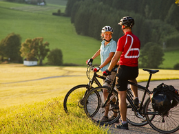
Get on your bike and discover your Innviertel. Top developed bike paths, culture and culinary delights in perfect variety and shady guest gardens with a promising beer and dumpling menu are already waiting for you.
Precious countryside
From the small eatery offering simple and rustic fare to the noble restaurant, the Innviertel is gastronomically well positioned. And thanks to the density of breweries - nowhere else in Austria are there more in one place - the beverage supply is also secured and the electrolyte balance is in equilibrium. Beer harmonizes perfectly with what we like to serve here: a crispy roast or dumplings in all variations.
The Innviertel Genuss Tour starts in Geinberg. On it goes to Kirchdorf am Inn to the European reservation lower Inn: The nature reserve with its untouched floodplain forest at the border between Lower Bavaria and Austria is meeting place for 300 different kinds of bird and up to 250,000 birds living there in the midst of one of the most unaffected river landscapes of Europe - what a singing scenery.
TIP: Don't forget binoculars!
Via the Innradweg cycle path R3 you continue to Obernberg am Inn. The Obernberg marketplace, with its rococo facades, is one of the most beautiful in Austria. The falconry Adlerwarte Obernberg, which is located in the castle area, offers impressive bird of prey demonstrations. Time for a break: a cool beer in the shady guest garden or for those with a sweet tooth a sweet Reidinger slice in memory of the "Es wird scho glei dumpa" songwriter and longtime pastor of Obernberg am Inn Anton Reidinger.
Freshly fortified, you continue on to Reichersberg. Visit the Augustinian canons' monastery Reichersberg with its vinotheque, garden and monastery store or take part in a guided tour of the monastery.
You continue on the Antiesenradweg cycle path (R23) into the valley of the Antiesen. On low-traffic side roads the Antiesenradweg leads via Münsteuer, Ort im Innkreis further to St. Martin im Innkreis. The cycle path leads past the Calvary Way of the Cross, the castle of the Arco-Zinneberg family and many typical Innviertel buildings.
You leave Utzenaich behind you and a bit off the Antiesen you come to Aurolzmünster, a village that was already elevated to the status of a market town in 1406. The origins of the market town go back to the year 800 after christ, when monks from the Bavarian monastery of Niederaltaich settled in the fertile area of the Antiesen Valley. Particularly worth seeing is the magnificent baroque castle Aurolzmünster in the center of the village, built between 1691 and 1711.
The Antiesenradweg cycle path then leads for about seven kilometers along the Antiesen brook to the district and trade fair town of Ried im Innkreis (half of the day's tour has been completed). The famous Schwanthaler family of sculptors lived and worked here for seven generations. Numerous guest gardens stores and the shopping center "WEBERZEILE" invite you to stroll.
TIP: Museum Innviertler Folklore house with works of all generations and style epochs.
Now the route continues along the connecting cycle path R104 to the Römerradweg cycle path. From the town center of Ried im Innkreis, the bike path leads in the direction of Neuhofen im Innkreis. Continue through the small Innviertel community on the little-used side road via Hauping, Bergetsedt to Magetsham. Here the R104 joins the Römerradweg R6.
On the last third of the route, however, there is still much to discover on the subject of "Romans". At the rest stops information boards inform about the life, the deities as well as the history of the Romans in the Innviertel. Shrubbery trails, a sewing machine museum or the church in Kirchheim im Innkreis are further stops for an informative break, and the innkeepers in Kirchheim im Innkreis have long ceased to be culinary insiders' tips.
TIP: Kirchheim airfield - pleasure flying.
On the last kilometers you have to pedal again, because from Polling im Innkreis you earn your top view with a little "uphill" feat of strength. At the Danner chapel, however, you will certainly be able to proudly look far into the Innviertel region, as far as Bavaria and the panoramic chain of the Alps. On the last 3 km downhill to the starting point "SPA Resort Therme Geinberg" you can let your impressions work again.
Cycle paths: R3, R23, R104, R6
- Suitable for groups
- Suitable for teenagers
- Suitable for single travelers
- Suitable for friends
- Suitable for couples
- Spring
- Summer
- Autumn
Please get in touch for more information.
Thermenplatz 2
4943 Geinberg
Phone +43 7723 8555
E-Mail info@innviertel-tourismus.at
Web www.innviertel-tourismus.at
")
")
")

")
")
")
")
")
Vis-à-vis users
1. The tours presented for hiking, walking, biking and road biking, mountain biking, motorbiking, horseback riding, climbing, cross-country skiing, and going on skiing and snowshoe tours etc. are to be considered non-paid tour recommendations and only serve as non-binding information. We have no intention of concluding a contract with the users of this website. The utilisation of the data does not lead to the establishment of a contract with us.
The data may only be used for private use; any commercial use is prohibited. In particular, it is not permissible to offer the data on commercially run websites, file-sharing platforms etc. or to use it to develop commercial products. Downloading data does not imply that users are granted rights to the data concerned.
The tour recommendations posted were created with utmost care; nevertheless, we assume no liability for the correctness and completeness of the information.
We point out that neither the tour recommendations included on this website nor the associated data and information were posted by us, but rather by third parties (Art. 16 Austrian E-Commerce Act). We have no influence on whether the details provided (e.g. distance, level of difficulty, change in altitude, description etc.) are authentic, correct and complete. We do not review these third-party contents. For this reason, we assume no liability for the authenticity, correctness and completeness of the information.
Construction-related measures or other influences (e.g. landslides and similar occurrences) can lead to temporary or permanent changes in a route (e.g. loss of a bridge and similar occurrences). Such occurrences can lead to part of the route or the entire route becoming impassable.
The use of the data as well as undertaking (riding, walking, taking etc.) the recommended tours or using the network of paths occurs at users’ own risk and on their authority. In particular, users themselves are responsible for the choice of route, outdoor orientation, adherence to traffic rules, supplies and equipment for tours listed in Point 1 (e.g. bicycle etc.), wearing a helmet, estimating their own fitness, recognising dangers and maintaining an appropriate velocity. We exclude ourselves from any liability whatsoever for damages, in particular accidents, that occur whilst taking part in the recommended tours.
2.Some of the tours lead over roads with normal traffic conditions. Please observe that there is an increased risk which can be avoided by means of appropriate attention and proper estimation and implementation of one’s own abilities. For this reason, please travel a route that is unfamiliar to you slowly and with special care. Pay constant attention to potential dangers and always observe traffic. Do not leave the routes featured in descriptions.
The potential use of private roads, in particular forestry roads and agricultural transport roads, can be subject to legal restrictions, which must be observed and adhered to.
The normal traffic rules apply. Each user (e.g. biker, motorbiker) is responsible for adhering to these rules and maintaining his/her bike/vehicle and its equipment (lights, brakes etc.) in good working order. Each user is also responsible for ensuring that he/she rides at a velocity that is appropriate for the conditions and his/her skill level and for maintaining sufficient distance to the rider in front. We explicitly recommend adjusting velocity to correspond to the respective field of vision, wearing a helmet, using reflective clothing (or similar) and employing bicycle lights in line with regulations.
3.Each tour requires good physical fitness as well as detailed planning. We explicitly recommend only taking the tours in the case of optimal healthiness.
We recommend that you conclude an accident and liability insurance policy. Use an onboard computer that displays the respective kilometres travelled per day and is calibrated for the front wheel.
4.Special for mountain bikers – Fair-play rules:
Mountain biking is one of the most wonderful outdoor leisure-time activities. Whilst biking or on a mountain biking tour, mountains and lakes, meadows and cabins are re-discovered in new ways. A couple of rules for fair play in the forest help to avoid conflicts whilst mountain biking.
a.Pedestrians have the right of way: We are accommodating and friendly to pedestrians and hikers. Upon encountering these fellow travellers, we alert them by using the bicycle bell and slowly overtake them. We avoid paths with heavy pedestrian traffic altogether. Take nature into account: We do not leave refuse behind.
b.The braking distance should be half of the total distance visible: We ride at a controlled pace, are ready to brake and maintain a braking distance half as long as the total distance visible, especially in curves, because we always have to count on obstacles on the path. Damage to the path, stones, branches, wood piles, grazing livestock, cattle grids, barriers, tractor-type forestry machines and authorised vehicles pose dangers that we need to be ready for.
c.Don’t drink and drive!: Do not drink alcohol when mountain biking. Take care at stop-off points (dealing with bike racks, dirty shoes or clothing).
It is obligatory to provide first aid!
d.Marked routes, closed paths and blockades: Keep to the marked routes, observe the blockades and accept that these roads are primarily for agricultural and forestry use!
Blockades can often not be avoided and are in your own interest. Biking beyond the intended path and outside of opening times is punishable and turns us into illegal bikers.
e.We are guests in the forest and behave accordingly, including vis-à-vis forestry and hunting staff. Whilst mountain biking, mobile telephones and music players are forbidden! Biking requires your full attention.
f.Avoid unnecessary noise. Out of consideration to the animals living in the wild, we only bike during full daylight. As a principle, we always wear our helmet (even when riding uphill)! Don’t forget emergency supplies: We always have a repair set and bandages along.
g.Don’t overestimate your skills: We should not overdo it when it comes to biking technique and physical fitness. Take the level of difficulty posed by the route into consideration and make a precise estimate of your experience and skills as a biker (braking, bell, lights)!
h.Close gates: We approach grazing livestock at a walking pace and close every gate behind us. We should avoid causing escape and panic reactions in the animals. Nothing stands in the way of the fun and athletic challenge in the mountains and forests!
i.Traffic rules: The general traffic rules (StVO) apply for all the mountain biking routes and we adhere to them. Our bike therefore needs to be in perfect technical condition and equipped in line with the traffic rules, including brakes, a bell and lights. We inspect and service our mountain bikes regularly anyway.
5.We assume no liability for the contents of external websites; in particular, we assume no liability for their statements and contents. Moreover, we have no influence on the design or contents of the websites to which hyperlinks on www.innviertel-tourismus.at lead or from which hyperlinks lead to www.innviertel-tourismus.at. There is no on-going review of websites to which hyperlinks on www.innviertel-tourismus.at lead or from which hyperlinks lead to www.innviertel-tourismus.at. We do not appropriate the contents of websites to which hyperlinks on www.innviertel-tourismus.at lead or from which hyperlinks lead to www.innviertel-tourismus.at.
Vis-à-vis bloggers
PLEASE OBSERVE:
1. Each of your tour recommendations for hiking, walking, biking and road biking, mountain biking, motorbiking, horseback riding, climbing, cross-country skiing, and going on skiing and snowshoe tours etc., along with other details and information, is free of charge. In particular regarding the correctness of the information, we assume no liability, nor do we assume any liability whatsoever for the consequences of the use of your tour recommendation by a third party (in particular by a user of this website). We do not review the tour recommendations you post, including other details and information, at any time.
We have no intention of concluding a contract with persons who post tour recommendations and/or other details and information on this website. Posting data (information) does not imply that a contract has been concluded.
By recommending a tour, we assume special responsibility vis-à-vis other athletes. Please take this responsibility seriously and describe your tour recommendation with utmost care and to the best of your knowledge and belief.
2.Your tour recommendations must therefore clearly and unambiguously include at least the following criteria and provide a sufficiently detailed description:
• Starting point
• Detailed route description
• Distance/Overall distance
• Level of difficulty
• Dangerous spots
• Average duration of trip
• Change in altitude
• Finishing point.
If possible, please provide the change in altitude.
3.When you post a tour recommendation, you give us the order to save your tour recommendation and/or the details you provide on our website and to make it/them accessible to third parties, in particular to users of this website, in the long term. We reserve the right to block or delete tour recommendations and/or other details and/or information that you post, either partially or entirely, at any time without providing a justification. Should this occur, it grants you no rights whatsoever.
Thank you for your efforts!
4. We are not responsible for the contents of external websites; in particular, we do not assume any liability for their statements or contents. Furthermore, we do not influence the design or contents of websites that can be accessed from www.innviertel-tourismus.at via hyperlinks or that use hyperlinks to refer to www.innviertel-tourismus.at. The websites that can be accessed from www.innviertel-tourismus.at via hyperlinks or that use hyperlinks to refer to www.innviertel-tourismus.at are not regularly monitored. Furthermore, we do not assume any claims to the websites that can be accessed from www.innviertel-tourismus.at via hyperlinks or that use hyperlinks to refer to www.innviertel-tourismus.at.